Overview
Global warming and climate change are present persistent threats to our planet, an urgent problem that the TDK Ventures team is passionate about addressing. Key solutions missing from the current technological landscape are methods by which to precisely measure real-time hyper-local water data to provide political leaders, first responders, property owners, insurance companies, and other stakeholders the information they need to mitigate the effects of water-related natural disasters and manage one of humankind’s most critical resources.
Divirod collects, maintains, and mobilizes environmental and satellite data to drive strategic decisions that mitigate the property, life-safety, and environmental risks posed by water. Whether there is too much, not enough, or it’s simply in the wrong place, water in all its states should be continuously monitored, measured, and controlled. TDK Ventures believes its investment in Divirod will expedite the company’s journey toward scaling and commercializing its water data products. By digitizing data describing sea levels, wave heights, river currents, lake depths, precipitation, snow accumulation, soil moisture level, and more, the company creates comprehensive, real-time representations of potential weather emergencies and developing trends. In essence, they will become “the Google Map for Water Data”.
Here we discuss why water management is such an urgent and motivating driver, and why we believe Divirod is a transformative innovator that can provide the accurate real-time dataset and advanced warnings to help mitigate economic losses from some of the greatest disasters that humanity can face in the future.
Motivation & Introduction
Fundamentally, our mission at TDK Ventures is to build a better tomorrow for all humanity. To do that, we seek out and empower the entrepreneurs and startups out there tackling the world’s most important challenges — we work to scale the impact they and their technologies can have on the world. Of the many challenges humanity faces today, none is more urgent than need for powerful adaptation and environmental transformation in the face of climate change.
We are at a point now where climate change is no longer something we can stave off or avoid, we are already living it. The long-term solution and key to sustainable, lasting, progress is pervasive global decarbonization. However, in the meantime humanity is also in need of immediate solutions to protect and cope with the current repercussions of climate change — climate adaptation. Any technologies working to address these challenges must consider one aspect above all others: water.
The reason our planet is habitable in the first place is because of water. It is our most precious resource, literally responsible for life. Climate change directly impacts our relationship with water on the planet — be it droughts and water scarcity, or storm surges, flooding, or other water related catastrophes.
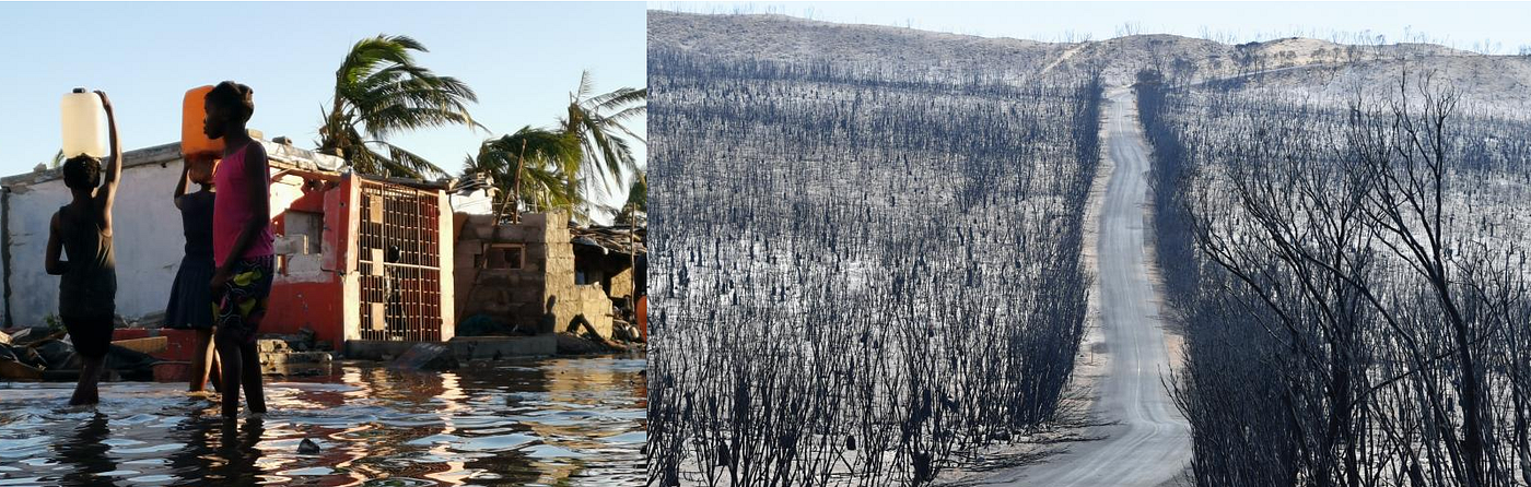
High-water events along 30 percent of the world’s coastlines that have been characterized as “100-year storms” with a 1 percent probability of occurrence in any given year, are projected to become “once-in-a-decade” events by mid-century [2]. It’s already happening; the last five years have seen no fewer than 10 climate events annually [3].
On the opposite spectrum of disaster, another key repercussion is scarcity and reduced access to viable water resources. According to the United Nations’ World Water Development Report, more than one-quarter of the world’s population already live in water-distressed areas. With demand for water increasing by upwards of 1 percent per year, shortages of fresh water for drinking, irrigation, industrial processes, and habitat sustainability will only grow [4]. By the end of the decade, it is estimated that 16 countries will be “unsustainably” drawing from their water resources to meet demand [5]. All stakeholders, including businesses, governments, humanitarian organizations, and others need to understand the risks associated with their geographic area of concern and the stresses and demands placed on lakes, rivers, and aquifers so they can design conservation efforts and devise strategies to ensure fulfillment of their missions.
Historical Solution
While dealing and adapting to climate-associated water risks has certainly attained a new urgency in recent years, the problem itself is far from new — nor are some of the standard solutions developed to address them. As summarized best in the previous section, the most important aspect of coping with these disasters has been in the ability to assess and predict the likelihood (and magnitude/severity) of potential risks for a given area so that strategic measures can be taken to prevent and mitigate potential emergences, or in some cases appropriately respond to imminent threats.
To meet these goals, the current standard solution is overwhelming reliance on weather and climate forecasting models to determine likely future conditions — of which flood risk, scarcity, and other aspects are then estimated. Initially these were informed solely based on historical trends and assuming patterns would be repeated which was often not the case, especially as overall environmental conditions shifted. In addition to limited accuracy, these predictive models “lack both spatial and temporal resolutions.” As a matter of fact, those climate and weather prediction models often provide predictions at the zip code level and had limitation to help in real-time decision making. As technology has progressed, satellite and Doppler radar tracking have significantly improved our modeling and predictive abilities, but despite these being incredible innovation, they too have limited viability in real time decision making as well as limited granularity/resolution of information yield.
Current solutions lack the robust data sets needed to deliver results that are accurate, timely, and detailed enough to inform the decisions needed. Thankfully, recent innovations in the data science, digitization, computing, and connectivity technologies offer the potential for modernization to supplement some of these shortcomings.
To start, many startup ventures are developing software and hardware to improve weather forecasting as a whole. As a way to improve accuracy, some of these are working to incorporate global-positioning satellites to collect data that presents point-in-time and longitudinal representations of earthly resources that can be analyzed and flowed into operational and forecasting models, and as such providing more real time informational updates. Other businesses are seeking to commercialize climate risk scoring, tailoring their approach to benefit specific use cases for insurance, agriculture, and similar industries. While critical, these platforms merely serve as foundations for comprehensive evaluation of water risk vulnerability driven by climate events.
Some of the most promising recent developments have been incorporating innovative satellite sensing and machine learning methodology to track and monitor water levels. These advances have granted water-risk monitoring platforms greater functionality but are still struggling with inaccurate baseline data inputs and inadequate sampling frequency hinders the usefulness in real-time decision making [6]. There are indeed several startups relying upon this approach. However, without new unique dataset and real-time ground-truth data as feedbacks to retrain the machine learning models, the differentiation among players will be limited.
Overall, real-time hyper-local data is what’s needed most including the infrastructure to collect and support the dissemination of said data. From this, the TDK Ventures team decided that one of the biggest impacts we could make would be a platform solution that could fill these data gaps in a way that could be readily deployed quickly, easily, and at sufficient resolution and output frequency to not only supplement predictive and forecasting efforts but provide real time monitoring and sensing capability for quick and effective decision making and emergency response.
A Comprehensive Path Forward with Divirod
Throughout our due diligence and deep explorations looking for technologies to address water-related catastrophes, Divirod quickly rose to the top as a global King of the Hill, and who we believe has the potential to change the game for the entire industry.
Divirod saw that monitoring and measuring the depth of seas and lakes, the rising of tides, and even the accumulation of rain and snow on the ground and rooftops was a largely manual process. Resource-intensive, prone to inaccuracies, and notoriously difficult to deploy and scale — thus limited an ability to combat and mitigate risk. Their solution? Divirod is deploying a specially designed radar system, utilizing existing satellite constellations and ground sensors which serve as transmitters and receivers of 24/7 data.
At any given time, several GNSS satellites orbiting the earth emit high energy microwave radars which are absorbed and reflected by multiple earth surfaces. Combining these satellite reflection signals produces an interference pattern that directly correlates to the parameters of the physical surfaces being monitored. Collating the signals generates detailed 3-dimensional map of water, snow, ice, and soil moisture over large surface areas. Their proprietary big data analytics instantly process and evaluate the data to detect all water sources and report levels, precipitation, flowrate, density, movement, soil moisture, and other insights.

Using such an approach, they are able to deliver:
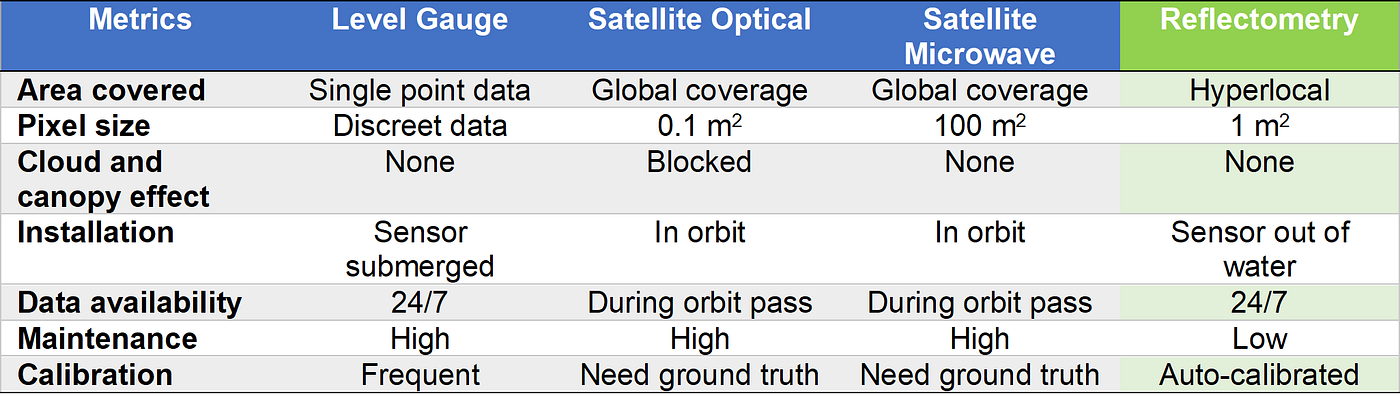
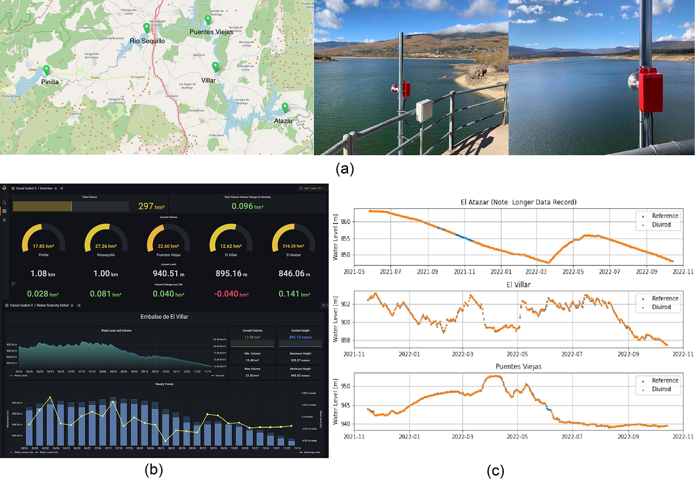
· Granularity — Hyper-local data with millimeter-level accuracy and high sampling frequency at every second combined with data analytics set Divirod apart from platforms that employ standalone optical or microwave satellite imaging. A combination of high spatial resolution and temporal sampling frequencies allows their system to monitor changes in rainfalls, snow melt and water flowrates along the river and shoreline in real time.
· Coverage — One sensor can provide a 3-dimensional map with acres of coverage. Networking multiple sensors along the reservoir, shoreline and a flood plain, and overlaying those data with real-time weather forecast and tidal models allows Divirod to aggregate intercomparable data points over time to create a predictive model, as well as an unparalleled reserve of historical and trendline insights that enable “improved situational awareness and disaster response to short-term and long-term water risk and resiliency planning for businesses and communities” [7].
· Cloud and Canopy Blockage — Divirod’s reflectometry technology operates in the microwave region of electromagnetic spectrum, so it can penetrate cloud, tree foliage, accumulated snow, and other obstructions that block optical satellites’ ability to obtain clear pictures of affected areas. Satellite-borne microwave imaging overcomes these obstacles as well, but at a cost in terms of data availability and resolution that often make it commercially unviable unless it is enhanced by ground truth sensor techniques.
· Plug and Play Solution — Divirod’s sensors begin collecting ground-truth-verified data immediately and continuously as soon as they are installed and powered up. Satellite imaging suffers from revisit lags. They can only collect data when they pass over the monitored area. Hours, days, and even weeks may elapse before they pass over the target.
· Low Investment and Low Maintenance Costs — Divirod’s hardware is several orders of magnitude lower cost compared to low-earth orbit or sub-orbital satellites. Their Data-as-a-Service (DaaS) model does not require customers to pay for upfront hardware costs. Maintenance of on-board satellite imaging systems must be performed at the operations level to optimize each instrument [8]. The effort must be coordinated with ground-truth verification to intercalibrate multiple dependent sensors’ focus and vision. Compared to existing water level sensors, they need to be submerged in water and is subjected to fouling that require frequent maintenance and recalibration. Divirod’s reflectometry-based sensors are not submerged in water. They are auto-calibrated and can be remotely monitored and updated.
Divirod water data network (with millimeter precision) fills critical geographic data gaps and augments currently existing, but outdated, sparse, and siloed environmental water-monitoring systems that are predominant today. In the immediate term, filling data gaps with Divirod datalake enables localized and real-time response for more-informed preparedness for and protection from impending water risks that threaten properties, economies, and, most importantly, human lives. Eventually, the increased captured data facilitated by global radar network coverage, will enhance stakeholders’ ability to arrive at smarter water-risk decisions and guide critical resiliency initiatives to greatly minimize future water risks.
One of the most useful aspects of the Divirod solution is that it is a comprehensive platform that can then be tailored and used for many applications. When combined with Big Data analytics, the infrastructure and output information can be used for anything from a water reservoir monitoring for resource management, a flood warning and monitoring system, to snow and ice monitoring approach to inform area warning systems.
The company has developed and deployed solutions for customers in various industries, such as:
1. Reservoir Management
– Tracking reservoir level, capacity, snow melt rate, and critical levels year round
– Monitoring waterway discharge rate and river inundation
– Measuring precipitation rates for snow, rain, and intensity
2. Real Estate
– Tracking of sea levels and wave activity with several hours of advanced warnings of destructive tidal surges
– Estimates of asset risk exposure to tidal conditions and coastal erosion
– Tracking of waterway discharge rates along river networks and provide advanced warnings to properties to deploy flood gates or preventative measures in the case of inundation prediction
– Notification of threats from water or snow accumulation on rooftops to prevent roof damage
3. Insurance
– Hyperlocal historical data for precipitations and snow accumulations for hazard insurance underwriting
– Retrospective evidence of the flooding magnitude and for parametric insurance claim settlement
4. Manufacturing Industries
– Monitor waterway discharge rates and stormwater systems and provide advanced warnings in case of flood predictions to provide enough time to deploy flood gates and mitigation measures
5. Smart Irrigation
– Continuous real-time monitoring of soil moisture level to adjust irrigation to conserve water, while avoiding dry spots
6. Enterprise Data
– Provide structured and labeled water data that are intercomparable with precise time stamps coming from GNSS’ atomic clocks. These accurate datasets are critical tothe accuracy of machine learning algorithm used in various climate models.
TDK Ventures’ Strategic Outlook: Why We Invested in Divirod
Divirod has successfully developed ground-truth radar system for water insights and is commercializing data-informed weather disaster warning system that can save countless lives, billions of dollars in property, and priceless habitats and environmental resources.
“Divirod is an incredible solution to a very dire social-equity gap. Flood risks and climate dangers affect hundreds of thousands and even millions of individuals every year,” said TDK Ventures President Nicolas Sauvage. “It has found a revolutionary way to enter the digital age for a sustainable benefit that can save lives with unit economics that will ensure ubiquitous coverage around the world. TDK Ventures is excited to partner with them and is determined to help Divirod accelerate its growth in any manner we can. The end results will be good for all of humanity, and that is exactly the kind of TDK Goodness we aim for.”
With the earth observation data services alone expected to reach $7.5 billion by the end of the decade and the private flood insurance market topping $9 billion, Divirod’s leadership, business model, and technological advancements leave TDK Ventures optimistic for a lucrative return on its investment. We believe that Divirod will lead the digitization of global water data and early water risk warning systems.
Their elegant and scalable solution is the product of a strong leadership team. CEO Javier Marti, Ph.D. is a veteran of the Space Industry, who traveled the world to build some notable space observatory projects, such as the $1.2 billion ALMA Observatory and the NEON Observatory. Co-founder and Chief Product Officer Adam Wilson is a serial entrepreneur who previously co-founded and scaled Sphero, an award-winning educational robot company that have sold millions of units to inspire young children to learn robotics and coding. Chief Technology Officer Heiko Udluft, Ph.D. was a project lead for advanced big data analytics development at AirSense, a subsidiary of Airbus. Together they have maneuvered Divirod into the nexus of climate adaptation and resiliency by digitizing and building the most unique, comprehensive, and accurate dataset for water.
As a takeaway message, we invested in Divirod for the future of climate resiliency and adaptation. They have checked all the boxes for our investment criteria:
1) Contributing to Society: They have one of the most impactful technologies that will help humankind adapt and become more resilience to climate change. While we all agree that the energy transition to a lower carbon economy must be done, we cannot lose sight that this will take decades to get to the Net-Zero economy. Economic losses from climate events are already happening and need to be addressed and mitigated urgently.
2) Financial Return: Absolutely. Their low-cost, high coverage, and real-time data platform offers unmatched solutions to several industries. It is unfortunate that the economic losses from climate change have been growing every year and is predicted to get worse in the next decades [10]. We are just at the beginning of the rise of the Climate Adaptation and Resiliency field. Divirod has the “triple threats” solution that provide real-time monitoring, predictive warning, and retrospective evidence of the water-risk events. Their growth journey has only just begun!
3) Strategic Fit: We invest in Digital Transformation and Energy Transition space and Divirod’s solution really cut across both domains. Digitizing water data will be the key to unlock insights needed to achieve climate adaptation and resiliency in decades to come.
Water is the most precious resource that has sustained lives on earth for millions of years. We need to manage it well, since it is the resource that we borrow from our future generations. When we put accurate and timely data in the hands of decision makers, we can better manage our most precious resource. This is why we invested in Divirod.
References
[1] 5 natural disasters that beg for climate action. (2022, May 25). Oxfam International. https://www.oxfam.org/en/5-natural-disasters-beg-climate-action
[2] Tebaldi, C., Strauss, B. H., & Zervas, C. E. (2012). Modelling sea level rise impacts on storm surges along US coasts. Environmental Research Letters, 7(1), 014032. https://iopscience.iop.org/article/10.1088/1748-9326/7/1/014033
[3] Lux Research (2020, June 18). Weather monitoring, prediction, forecasting. Lux Take. https://members.luxresearchinc.com/research/technology/346040
[4] Pltonykova, H., Koeppel, S., Bernardini, F., Tiefenauer-Linardon, S., & de Strasser, L. (2020). The United Nations World Water Development Report 2020: Water and Climate Change. https://aquadocs.org/handle/1834/42227
[5] Koroui, A, & Zerter, L. (2022). Water-related risks and challenges: a quantitative research perspective. Morningstar Sustainalytics. SUST_261_RESEARCH_PAPER_WATER_SUMMARY.pdf (sustainalytics.com)
[6] Piesse, D. (2022, Sept. 13). The internet of the sky: space, remote sensing, ESG, and cybersecurity. International Insurance Society. https://www.internationalinsurance.org/intelligence_internet_of_the_sky_space_remote_sensing_esg_cybersecurity
[7] Fischer, A. (n.d.) Predicting hyper-local impacts of sea level rise. Environment Coastal & Offshore (ECO). http://digital.eco-tsc.com/publication/frame.php?i=714154&p=&pn=&ver=html5&view=articleBrowser&article_id=4072728
[8] Dubovik, O., Schuster, G. L., Xu, F., Hu, Y., Bösch, H., Landgraf, J., & Li, Z. (2021). Grand challenges in satellite remote sensing. Frontiers in Remote Sensing, 2, 619818. https://www.frontiersin.org/articles/10.3389/frsen.2021.619818/full
[9] Marti, J., Udluft, H., Harvey, T., van Anda, D., “Digitizing end-to-end water asset monitoring and forecast,” Symposium on Management for Safe Dams, 91st Annual ICOLD Meeting, Gothenburg 2023.
[10] The economics of climate change: no action is not an option (2021). Swiss Re Institute. https://www.swissre.com/institute/research/topics-and-risk-dialogues/climate-and-natural-catastrophe-risk/expertise-publication-economics-of-climate-change.html